


Metro (subway) in Amsterdam:
info, tickets, map 2026
Anyone who wants to explore Amsterdam using public transport will hardly be able to avoid the metro. It connects central districts with the surrounding areas and perfectly complements trams and buses.
- This travel guide provides an overview of routes, tickets and important usage tips specifically for tourists.
- With our tips on buying tickets, you can save both time and money.

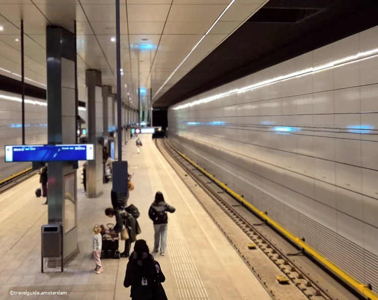
Most of the metro in Amsterdam runs above ground. The metro only runs underground in the city centre.
Tickets for public transport in Amsterdam:
Which ticket option is best for me?
- The Metro in Amsterdam is operated by the municipal company GVB, which is also responsible for the tram, bus, and ferries.
- Whether single ride via e-purse, also referred to as OV-card, GVB day ticket or “Amsterdam Travel Card”, ➡️you will find detailed information for all, as well as current fares here. It allows you to quickly and easily find the right ticket option for your stay in Amsterdam.
Knowing which ticket option works best for you will save you time and money after arrival and help you avoid stressful situations.
Our tip if you don’t want to deal with fare systems and ticket machines:
Single-day and multi-day tickets for Amsterdam’s public transport system are usually the best option for visitors.
- These tickets allow unlimited use of the metro, GVB buses, trams and ferries for the entire period of validity (1–7 days).
- Compared to other major European cities, these tickets are reasonably priced. For 2026, fares range from €6.15 to €10 per day, depending on the length of validity.
Convenience:
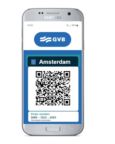
You can purchase these tickets online before your trip at no additional cost 👉 via the website of the authorised GVB ticket seller – click here –. You will not have to deal with ticket machines or the tariff system upon your arrival.
This means you won’t have to deal with ticket machines or fare systems after arrival. Your ticket will already be available on your smartphone.This saves time and reduces stress, allowing you to focus on enjoying your stay in Amsterdam.
Lines and route network
The Amsterdam metro (Dutch: Amsterdamse metro) serves Amsterdam and the surrounding municipalities of Diemen, Amstelveen and Ouder-Amstel. Compared to cities like Paris or London, Amsterdam’s metro system is relatively new. The first line only went into operation in 1977.
Metro facts:
- Current lines: 5
- Stops: 39
Special features:
- Three of the five lines start at Amsterdam Central Station.
- Line 50, also known as the ‘ring line’, is the only line that does not pass through the main station.
More than 50 metro lines in Amsterdam?
The metro in Amsterdam currently (as of 2026) consists of five lines and 39 stops.
The numbering of the lines starts with 50, so at first glance the route network appears more complex than it actually is.

Amsterdam has a modern metro. In the outskirts of the city, the trains do not run underground.
Line 50
Line 50 connects the south-eastern and western districts of the city without crossing the city centre.
Line 50 is also called the Ringlijn (ring line). It is the only line that does not pass through Amsterdam Centraal station.
The final stops are “Isolatorweg” in the northwest and “Gein” in the southwest. With the stop “Bijlmer Arena” it also serves the well-known football stadium Johan Cruyff Arena.
Almost all stations on this line were built to a standard design. Most subway stations have a central platform, which passengers can access via escalators and an elevator.

The “Bijlmer ArenA” stop of lines 50 and 54 is near the Johan Cruyff Arena (formerly Amsterdam Arena). It is also an important station for Dutch railways.
Line 51
Line 51 starts at the central station “Amsterdam Centraal” in the city centre. Here, the line runs in the first metro tunnel from the central station to the “Amstel” stop.
Change of route
Since 2020, line M51 no longer turns southwest at the south station “Zuid” (terminal stop “Amstelveen”), but runs parallel to line 50 to terminal stop “Isolatorweg”.
If you are using an older route map, it may be confusing.

The M51 at the “Waterlooplein” metro station. Three of Amsterdam’s five metro lines intersect here: 51, 53 and M54.
Linie 52
The new line 52 runs to Zuid station or north to Noord station.
Construction of metro line M52 (also Noord/Zuidlijn) started in 2002. It was completed in 2018.
It runs from Zuid station northwards via Central Station to Noord station. A southbound extension of route 52 to Amsterdam Airport Schiphol is planned.

The station “Europaplein” of line 52. The metro line is also called Noord-Zuidlijn (“North-South Line”) and was completed in 2018. (Image: Johan Wieland, CC BY-ND 2.0 license)
Since 2018, the north of Amsterdam has also been connected to the metro network.
It is the first line to cross under the IJ (Zuiderzee estuary) through a tunnel. This means that the northern parts of the city are also connected to the subway network.
Lines 53 and 54
Lines 53 and 54 provide a connection from the city centre to the areas of Diemen, Duivendrecht in the southeast.

Lines 53 and 54 run parallel in the city centre. From the “Van der Madeweg” metro station, the lines separate. Line 54 heads south, while line 53 heads east.
Route network plan / map for download
⬇️Download: Map- Metro lines in Amsterdam / Network map (250kByte)
⬇️ Download: Map – Metro lines and tram lines in Amsterdam / route network plan (as of 2025 / 2026)

The GVB metro allows you to travel quickly and cheaply within Amsterdam. (Image: Tom Page, CC 2.0 licence)
Tips for passengers
- Keep your ticket until the end of the journey
When you enter the metro station, your ticket is automatically checked. Do not throw the ticket away afterwards. Your ticket will also be checked again at the exit.
Your ticket will be checked at these readers when you enter and leave the metro station. Therefore, keep your ticket until after you leave the metro.
- Day and multi-day tickets quickly pay off
If you plan to make more than just a single journey, a day or multi-day ticket is usually the best option.
With this ticket, you can use the metro, GVB buses, trams and ferries unlimited and free of charge for the entire period of validity (1–7 days).Compared to other major European cities, these tickets are reasonably priced. In 2026, prices range from €6.15 to €10 per day, depending on the selected period of validity.
Online tickets – save time and effort
You can purchase these tickets online before your trip at no additional cost. This means you won’t have to deal with ticket machines or fare systems once you arrive in Amsterdam.
This saves time and stress – there are better things to do in Amsterdam …
Safety: Pickpockets on the Amsterdam Metro
As in many large cities, pickpocketing occasionally occurs in the Amsterdam metro, especially at peak times and at busy stations such as Amsterdam Centraal.
The thieves often work in groups and use distraction tactics to get hold of valuables.
Safety tips for passengers:
- Do not carry backpacks on your back, but in front of your chest.
- Always keep an eye on your valuables and store them securely.
- If possible, use closed jacket or inside pockets.
- Watch out for diversionary tactics such as artificially created crowds.
- Take only the essentials with you and avoid showing expensive items.
Emergency numbers: If something is stolen, report the incident immediately to the police or GVB service personnel.
Contacting the police
Telephone number: 0900-8844 (if using a mobile phone with an international SIM card, dial +31 343 578 844)
internet: online reporting
Do you have any other tips or experiences? Your comment may help other readers of this guide.
The metro in Amsterdam is modern, clean and well organised. Nevertheless, as in any major city, travellers should keep an eye on their valuables.
History of the metro in amsterdam

The logos of the Amsterdam Metro and its operating company, the GVB, often point to the nearest Metro stop.
Compared to other European metropolises such as London or Paris, the metro in Amsterdam is still very young.
The first ideas for a metro in Amsterdam already existed in the 1920s. But the economic crisis and the Second World War put a stop to these ideas.
Growing prosperity after the war and the associated motorisation of the population caused traffic problems to grow, and not only in Amsterdam. Many cities in Europe now began to implement the pre-war plans. At the end of the 1950s, for example, construction began on the metro in Lisbon.
Construction begins
Amsterdam began planning the metro in earnest in the 1960s. The first plan included a metro network with 4 lines that would replace many of the existing tram lines.
In 1970, construction began on the Oostlijn (East Line), which connects the city centre with the eastern districts of Bijlmermeer and Amstel. Here, part of the lines, especially outside the city centre, already ran above ground.
Since Amsterdam wanted to take a pioneering role as a city without car traffic, the metro network and the bicycle infrastructure were significantly expanded. In this way, Amsterdam has secured a leading position among European metropolises in the field of “mobility without cars”, also thanks to its modern metro.
FAQ 2026: Pets (dog, cat …), bicycle, folding bike …
How can dogs or pets ride on the Amsterdam Metro?
The local transport company GVB is very animal-friendly. Pets, including dogs, can ride on the metro for free. They must be in a bag or box, or on your lap, or on a short leash.
What are the rules for taking bicycles on the Amsterdam Metro?
- In general, bicycles can be taken on the metro outside rush hour. An extra ticket must be purchased for the bike.
- Rush hour when bicycles are prohibited:
Mon. – Fri. 7:00 a.m. to 9:00 a.m. and 4:00 p.m. to 6:30 p.m. - A folding bike is considered hand luggage and can therefore be taken on the subway free of charge.
Is there a metro (underground) in Amsterdam?
Yes, the metro in Amsterdam consists of five lines and 39 stations (as of 2026). A large part of the metro routes run above ground. That is why the metro is often confused with the tram.
How much does a Metro (subway) ticket cost in Amsterdam 2026?
There is no single ticket with a fixed price regardless of the route length. You can load credit onto the OV card (E-Purse) and then use it.
In 2026, the basic price will be €1.16 per trip plus 21.7 cents per kilometer.
It’s easier with the day ticket. This ticket gives you unlimited use of all GVB trams, city buses, metro (day and night) and ferries throughout Amsterdam.
Is there a stop of metro subway near to Budget hotel Neutraal Amsterdam1012 LG?
Hello Yeoh,
the address of your hotel is “Damrak 8, 1012 LG Amsterdam, Netherlands”. This is right in the city center. The main train station “Centraal Station” is about 100m away. This is a transport hub for metro, train, bus, tram and ferries.
Have fun in Amsterdam
What hours does public transportation run in Amsterdam? Where can I find a schedule?
Hello Jason,
Metro operating times 2025:
The Amsterdam metro starts every day at 6am and ends at 12.30am (midnight). Trains usually run every 10 minutes.
Have fun in Amsterdam